When I was in Montréal a week ago, I made a point of visiting the new Promenade Fleuve-Montagne.
The Promenade is a 3.8 km walkway between the old port on the Saint Lawrence (the “fleuve”) and the base of Mount Royal (the “montagne”).

Map showing the location of the Promenade Fleuve-Montagne and the Métro. GIS data from BBBike.org and MetroExtracts versions of OpenStreetMap. On this map (unlike on the tourist map below), north is at the top.
It was established to mark the 375th anniversary of Montréal’s founding. The official literature on the Promenade stresses its symbolic importance. Its endpoints, for example, are described as the “two natural iconic features of the city.” The Promenade has been covered at great length in the local press,1 and it appears prominently on Montréal’s latest official tourist map.

Small fragment from the current official tourist map of Montréal: Montréal, carte touristique officielle, 2017-2018 = official tourist map, 2017-2018. Montréal : Tourisme Montréal, 2017. The Promenade Fleuve-Montagne is shown in very dark blue. North is to the top right. As is the case with many maps of Montréal, this map puts the Saint Lawrence along the bottom margin.
I found the Promenade somewhat disappointing. It generally just follows ordinary (if occasionally prettied-up) sidewalks, and the most visible indications that one is on the Promenade are yellow and blue triangular markers that appear on light poles or (more rarely) on altitude markers.

Avenue McGill College looking north. The only way one would know one is on the Promenade Fleuve-Montagne is the altitude marker in the lower left.

One of the altitude markers that come along every so often on the Promenade.
There are also a few Promenade logos painted on sidewalks. But it would actually be extremely difficult to follow the Promenade using the markers alone, since they disappear in places (for example, along the Rue Sainte-Catherine)—and there are no signs that I could see telling walkers that they should make one of the Promenade’s seven or eight L-shaped turns. There are also no new historic markers along the Promenade, even though its route was chosen in part because it passes interesting buildings. One block on the McGill campus—Rue McTavish—is a partial exception to the above generalizations. It’s been pedestrianized (and is the block shown on the official Website). There are also a couple of blocks along Avenue McGill College with extra-wide sidewalks that are used for exhibitions. But these sidewalks were widened several years ago, long before the Promenade was established.
Let me add that the Promenade is a perfectly pleasant place to walk, and a pedestrian following it with the Promenade tourist brochure2 in hand could learn a great deal about the buildings along the way. But the Promenade is much more like any number of somewhat artificial tourist paths (for example, the Freedom Trail in Boston) than an important new piece of infrastructure, and it’s not nearly as well-marked as its competitors in other cities.
Montréal actually doesn’t have an enormous need of new pedestrian infrastructure, at least in the parts of the city that the Promenade runs through. For a North American urban area with a population of approximately four million, it already has superior pedestrian facilities. Montréal is in fact one of best walking cities on the continent. Its diffuse central business district is surrounded (and increasingly interpenetrated) by dense, safe, and interesting residential areas, which contain a great deal of thriving small-scale commerce. As a result, pedestrians are common over quite a substantial area, even in the worst winter weather. Montréal’s major commercial street, the Rue Sainte-Catherine, is so crowded in places that it’s impossible to walk fast and, perhaps because of this, it already has two pedestrianized sections, one in the entertainment-oriented Quartier des Spectacles and the other (in the warm season only) in the “Gay Village.”

A pedestrianized area along Rue Sainte Catherine in the Quartier des Spectacles.
There are also pedestrianized areas in Old Montréal. In addition, there are said to be 32 km of tunnels and skybridges in Montréal’s Ville souterraine (“Underground city”), which are of course particularly useful during Montréal’s long winter.
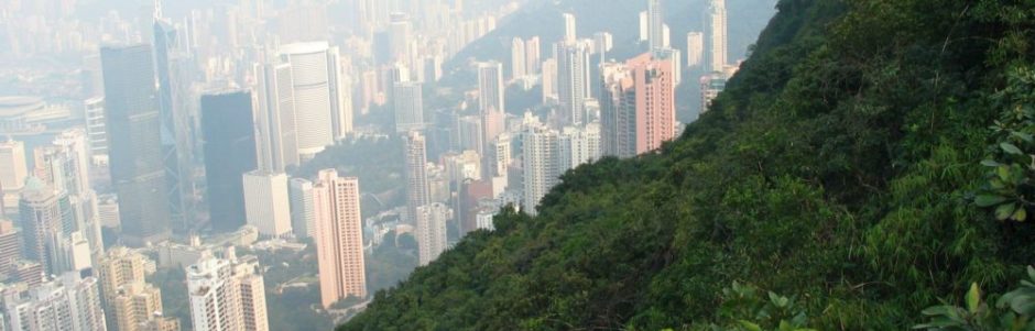
Montréal‘s most striking feature may be Mount Royal itself, a 233 m hill that sits next to the central business district. The park on Mount Royal, in part designed by Frederick Olmsted, includes both gentle and steep trails to the summit that are used intensively by walkers, runners, and cyclists. Every time I go to Montréal I feel jealous that I don’t live in a city that has a substantial hill next its downtown.

The Chemin Olmsted in Mount Royal Park. There are also steeper trails.
Montréal has actually played a significant role in the slow improvement in pedestrian and transit facilities in North American cities over the last sixty years. Its Métro (1966) was the first modern North American subway system with stations self-consciously designed to be aesthetically pleasing. (The earlier postwar subway systems in Toronto and Cleveland were much more austere.)
Montréal was also one of the first North American cities to establish an elaborate network of urban bicycle paths in the modern era. The trail along the Canal de Lachine opened in 1978, when the canal was still lined with industrial buildings. Since then, the trail right-of-way has been improved with the addition of a separate gravel path for pedestrians, and the city has acquired numerous additional pistes cyclables (“bicycle trails”).

Paths along the Canal de Lachine. Note the apartment building under construction on the left. The once industrial areas along the Canal de Lachine have been acquiring somewhat expensive high-rise housing in recent years.
Montréal pioneered protected bicycle facilities in regular streets as well. The original protected routes were set up to disappear in winter, but the latest routes are permanent. In the summer at least bicycles appear to make up as large a portion of central-city traffic as in any major North American city.

The protected bicycle path along the Boulevard de Maisonneuve.
The Promenade Fleuve-Montagne struck me as being a pleasant but perhaps not altogether necessary addition to Montréal’s non-automotive transportation infrastructure.
- See, for example, the following stories in Le devoir, Québec’s “serious” Francophone newspaper: Valérie Beaulieu, Robert Turgeon, and Sylvie Guilbault, “Promenade Fleuve-Montagne, de l’âme et du sens,” Le devoir, 7 August 2017; Jeanne Corriveau, “La promenade Fleuve-Montagne a coûté 49,7 millions et non de 55 millions, dit Réal Ménard,” Le devoir, 18 July 2017; and many other articles over the last several years. ↩
- La Promenade Fleuve-Montagne. Montréal : Vive375, 2017. ↩